NASA Satellite Images Show Dramatic Decreased Lake Mead Water Capacity, Image/NASA
Lake Mead is a reservoir which straddles Arizona and Nevada in the United States. In 1935, the Hoover Dam was built and the Colorado River was significantly altered. Lake Mead has varied in water level over the years. The lake last achieved full capacity in 1983 and 1999.
Lake Mead’s water comes from varied sources, a majority coming from the Colorado River watershed:
“About 10 percent of the water in Lake Mead comes from local precipitation and groundwater each year, with the rest coming from snowmelt in the Rocky Mountains that flows down the Colorado River watershed through Lake Powell, Glen Canyon, and the Grand Canyon.”
Currently Lake Mead water levels are at their lowest since April 1937, continuing a 22-year downward trend, when the reservoir was still being filled with water from the Colorado River. On July 18, 2022, Lake Mead reached just 27 percent of water capacity:
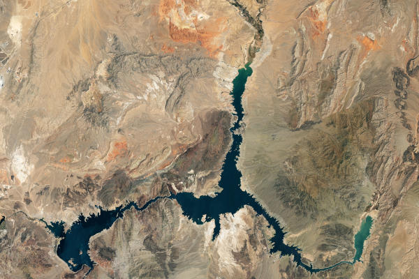
“As of July 18, 2022, the water elevation at the Hoover Dam was 1041.30 feet (317.4 meters) above sea level; the water elevation at the end of July 2000 (around the time of the Landsat 7 image above) was 1199.97 feet (341 meters). Lake levels at the dam should stay above 1000 feet to continue operating hydropower turbines at normal levels.”
Lake Mead is the largest reservoir in the United States provides water to millions of people across seven states, tribal lands, and northern Mexico.

Lake Mead natural-color images above were acquired on July 6, 2000, and July 3, 2022, by Landsat 7 and Landsat 8, Image/NASA
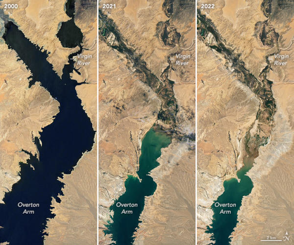
Using Landsat 7 and Landsat 8 data from the U.S. Geological Survey and and lake elevation data from the Bureau of Reclamation, the NASA Lake Mead images show the effects of severe drought on the Colorado River watershed:
“The natural-color images above were acquired on July 6, 2000, and July 3, 2022, by Landsat 7 and Landsat 8. The detailed images below also include a view from Landsat 8 on July 8, 2021 (middle). The light-colored fringes along the shorelines in 2021 and 2022 are mineralized areas of the lakeshore that were formerly underwater when the reservoir was filled closer to capacity.”


